When hurricanes, flooding, or severe storms impact South Florida, property owners are often left trying to prove the condition of their homes, roofs, businesses, or land before and after the damage occurred. Unfortunately, many insurance claims become delayed, disputed, or underpaid because there is not enough visual evidence documenting the property.
That’s where professional drone property documentation can make a major difference.
At Nuntius Aerial Media, we provide high-resolution aerial photography, video documentation, and 360° property imaging designed to help homeowners, real estate professionals, property managers, and business owners create accurate visual records of their properties before and after storms.
Why Drone Documentation Matters
Traditional ground-level photos often fail to capture the full condition of a property — especially roofs, large lots, drainage areas, fencing, or commercial structures. Drone technology allows for a complete aerial perspective that provides clearer and more detailed documentation.
Drone documentation can help capture:
-
Roof condition and storm damage
-
Property boundaries and land conditions
-
Flooding or drainage issues
-
Exterior structural damage
-
Fallen trees and debris impact
-
Commercial building conditions
-
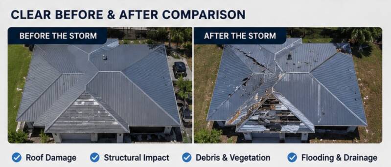
Before-and-after comparisons
This type of visual evidence can help support insurance claims by creating a time-stamped record of the property’s condition.
The Analytics Behind Property Documentation
According to the Insurance Information Institute, weather-related events account for billions of dollars in property losses annually across the United States. In Florida alone, hurricane and storm-related claims continue to increase each year due to stronger storms and rising property values.
Industry studies also show:
-
Roof-related claims are among the most disputed insurance claims because of limited visual evidence.
-
Properties with detailed visual documentation often experience faster claim processing compared to claims with minimal evidence.
-
Aerial imagery can reduce the need for repeated site inspections by clearly documenting hard-to-reach areas.
-
Drone inspections can capture angles and elevations that are impossible or unsafe to obtain manually.
For large properties, commercial sites, and acreage, drone documentation provides significantly more coverage in less time than traditional photography methods.
Why Pre-Storm Documentation Is Critical
Most property owners wait until after a storm to document damage. However, pre-storm documentation is often the most important part of the process.
Without proof of the property’s original condition, insurance companies may question:
-
Existing roof wear
-
Prior structural damage
-
Fence conditions
-
Drainage issues
-
Exterior deterioration
Pre-storm drone documentation creates a visual baseline that can help demonstrate what changed after the event occurred.
360° Documentation Adds Another Layer of Protection
In addition to aerial photography, 360° virtual documentation provides a complete interactive view of the property.
This can help document:
-
Exterior structures
-
Interior conditions
-
Inventory and equipment
-
Commercial spaces
-
Large residential properties
360° tours allow property owners to revisit the exact condition of a property long after the inspection was completed.
South Florida Storm Preparedness Starts Before Hurricane Season
In South Florida, hurricane preparation is no longer optional. The combination of hurricanes, flooding, tropical storms, and severe weather makes property documentation an important part of protecting your investment.
Professional drone documentation provides:
-
Time-stamped visual records
-
High-resolution aerial imagery
-
Safer roof inspections
-
Faster large-property coverage
-
Better before-and-after comparisons
Protect Your Property with Professional Drone Documentation
At Nuntius Aerial Media, we help South Florida property owners document homes, businesses, land, and commercial properties with professional drone photography and 360° virtual imaging services.
Whether you need pre-storm documentation, post-storm inspections, or complete aerial property coverage, our team is ready to help.
Services Include:
-
Pre & Post Hurricane Documentation
-
Drone Roof Inspections
-
Aerial Photography & Video
-
360° Virtual Tours
-
Land & Acreage Documentation
-
Commercial Property Imaging
Ready to Protect Your Property?
Visit Nuntius Aerial Media to schedule your professional drone property documentation service today.
Add comment
Comments